|
NOAA HRPT - High Rate Picture Transmission
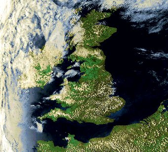
Click on the picture to expand it
The High Rate Picture Transmission (HRPT) service installed on the NOAA satellites has for some two decades been the main source of high quality data from polar orbiting meteorological satellites at major user stations throughout the world.
The data stream not only contains full resolution images in digital format from the AVHRR instrument but also the atmospheric information from the suite of sounding instruments.
Through HRPT reception the user site can acquire data from three or more consecutive overpasses twice each day from each satellite, giving high resolution data coverage of a region extending to about 1500 km radius from the user station.
The imagery gives a snapshot of the meteorological conditions and can also be used for many land and ocean applications, while the sounding data gives detailed atmospheric data that may be processed and used in regional Numerical Weather Prediction (NWP) models.
The NOAA HRPT system provides data from all NOAA-K,L,M spacecraft instruments at a transmission rate of 665,400 BPS.
The real-time transmissions in S-band (at around 1700 MHz) include the digitised unprocessed output of the following sensors:
Imaging Instrument
The Advanced Very High Resolution Radiometer/3 (AVHRR/3) with its 1.1 km resolution dominates the data rate of the HRPT broadcast.
Five spectral channels out of a possible range of six are transmitted in full resolution at any one time, together with relevant calibration data. Channels 3A and 3B cannot be transmitted at the same time.
The selection is made by telecommand from the ground control centre and the selected channel indicated in the telemetry.
The onboard processor also generates Global Area Coverage (GAC) and Local Area Coverage (LAC) formats from the original AVHRR data.
These data are stored onboard and downloaded separately from the real-time data stream transmitted by HRPT.
Atmospheric Sounding Instruments
The atmospheric sounders on the NOAA-K,L,M spacecraft comprise the suite of instruments known as the Advanced TIROS Operational Vertical Sounder (ATOVS).
This includes the Advanced Microwave Sounding Unit-A (AMSU-A) for atmospheric temperatures, the Advanced Microwave Sounding Unit-B (AMSU-B) for atmospheric humidities and the High Resolution Infrared Radiation Sounder/3 (HIRS/3) for atmospheric sounding in cloud-free regions.
Data from all three of these TOVS instruments are included at full resolution in the HRPT broadcast. On NOAA-N and NOAA-N', data from the Microwave Humidity Sounder (MHS) provided by EUMETSAT will replace AMSU-B data.
The Solar Back scattered Ultraviolet (SBUV) instrument measures atmospheric ozone: its data are also transmitted by HRPT
HRPT Transmission Characteristics
360 AVHRR lines/minute
5 transmitted, 6 available
Data Resolution Digital split phase, phase modulated
1698.0 or 1707.0 MHz
Other Facilities
The HRPT data stream also contains data from the Solar Environment Monitor (SEM) and the ARGOS Data Collection System (DCS).
The table above shows the general characteristics of the HRPT transmission system: It should be noted that a new version of HRPT is to be implemented on the future Metop satellites to be operated by EUMETSAT.
While Metop HRPT will follow the same general concept of transmitting most of the instrument in full resolution in real-time, due to evolving technology and new data transmission standards, the newer system will not be compatible with the HRPT system outlined here
Sources: NOAA/NESDIS 1315 East-West Highway Suite 15400 Silver Spring Maryland USA.
Further reading NOAA-KLM user's guide
|

